Point Database
Main Menu | Data Manager | Point Database
The point database dialog is used to review, edit, and manipulate your point data in your Project database. The list will display all points currently stored in the database, and the data can be sorted by pressing the column headers.
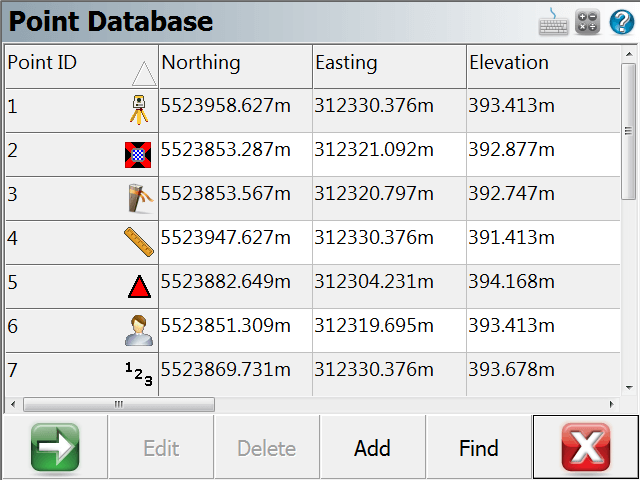
Point ID (Survey Role) Icons

|
The instrument icon indicates your current occupied point. |

|
The target icon indicates your current backsight point. |

|
The stake icon indicates points that are to be |

|
The checked stake icon indicates points that have been |

|
The hub icon indicates control points, they cannot be edited under any circumstances. |

|
The user icon indicates user entered points, the coordinate can be edited. |

|
The ruler icon indicates measured points, the coordinate cannot be edited. |

|
The 123 icon indicates calculated points, the coordinate cannot be edited. |

|
The stake and square icon indicates a Staked and Stored point. The Staked and Stored survey role is unique and not associated with LandXML schema. |
Note:
To edit the coordinate of a measured or calculated point, you must first change its survey role to user entered.
Next/Previous
Use the green arrow button to display the next button sets for more options.
Edit
Use this to edit the coordinates of a point that is highlighted in the list using the Store/Edit Points tool. Remember you must change the Survey Role to User Entered.
Delete
Use this to delete the current point or selection in the list. Note: There is no undelete point option in FieldGenius. If you delete points from the coordinate database they cannot be restored
Add
Use this to open the Store Point screen to manually enter a new point.
Find
Use this to select multiple points, based on a single point ID, a point ID range, a point coordinate range, or point descriptions.
RTS (Rotate/Translate/Scale)
Use this to rotate or translate your points that are currently selected in the coordinate list. When you press the button you will see the Rotate / Translate / Scale Points screen. Please refer to the Rotate / Translate / Scale topic for more information.
Local Transform
Use this to apply a coordinate transformation to a point or selection in the coordinate list. You need to have calculated the transformation parameters prior to pressing this button. See the
Statistics
Use this to display statistics of the coordinate database, including the total number of points, bounding minimum and maximum coordinate values, and point ID's in use, and point ID's not in use.
Map View
Use this to display the currently highlighted points on the screen.
Average
Press this button to enter the Point Averaging routine.