Rotate/Translate/Scale Points
Apply User Defined Parameters
Main Menu | Calculations | Rotate/Translate/Scale | Apply User Defined Parameters
Use this to rotate, translate and scale a point or group of points by entering the parameters. When this command is used notes will automatically be written to the raw file indicating what parameters were entered by the user. Coordinates that are updated with the RTS command will be recorded in the raw file with AP (Adjusted Points) records.
The RTS command has the three options located on separate screens. The user can specify more than one option at the same time, for example you could rotate a group of points by 45° CW, then translate them 25' east. This can be done in one operation, instead of two separate ones.
All of the fields have extended edit functionality. On the direction or distance fields, if you double tap them you will see a popup menu. From there you can start the calculator or use the inverse command.
When using the inverse option, simply type the two numbers for the inverse, then press the ESC key to automatically copy the value that was computed during the inverse.
The RTS function can also be accessed from the coordinate database. Accessing it from there allows you to select your points form the list which in some cases might be easier than entering a point range.
Rotate: Simple Angle
This is the simplest form of rotating your points. Specify the base point for the rotation, and a rotation angle.

Rotation Base Point
Use this to specify the pivot point for the rotation. You can select the point by double tapping in the edit field. Use the point chooser to select the point form the map, or simply enter the point number.
Rotation Angle
Specify the desired rotation in degrees, minutes seconds (or whatever your project units are set to). You can also use the direction recall feature and enter #..# to inverse between two point numbers.
Rotate: Azimuth Difference
This allows you to define two azimuths, usually used to compute the angle needed to rotate a group of points to match a field azimuth to one from a plan.

Rotation Base Point
Use this to specify the pivot point for the rotation. You can select the point by double tapping in the edit field. Use the point chooser to select the point form the map, or simply enter the point number.
Original & Destination Direction
Specify the desired rotation in degrees, minutes seconds. Depending on your project units, you will be entering either a bearing or an azimuth. You cannot use the direction recall feature such as #..#. Instead use the inverse command that appears when you double tap the field.
Translate
Use this option to specify a shift to a point or group of points. The translation is separated into three groups, shift from point to point, shift by coordinate change and shift by direction and distance. In most circumstances you will only need to use one of the three types, but you can use them in conjunction with on another if you need to.
For example, you could specify that the points are to be shifted by coordinate difference between points 10 and 20, then shifted again to the east by 50 feet.

Original & Destination Points
These work in conjunction with one another. The difference in coordinates to get from one point to the other is calculated and added to all points. You can use the point chooser to select your points or simply type the points in the fields. The horizontal differences in the northing and easting is computed and applied to the points being transformed. The elevation of the points will remain unchanged.
Add Northing, Easting, Elevation
Any one or combination of these shifts can be applied. Simply input the value for each shift in the appropriate fields. Both negative and positive values are valid.
Add Direction and Distance
Define the shift by direction and distance. The coordinate shift in Northing and Easting will be calculated using the direction and distance you enter in the fields. If desired you may apply two shift components at the same time. For example, shift your selection of points by Direction and Distance, but also add 100.00 to the elevation. You can use angle and distance recall features to help you compute your answer.
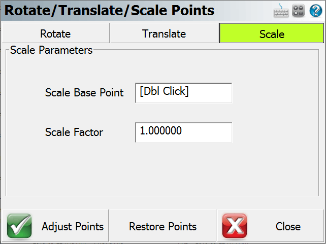
Scale
You can scale a group of points using the scale option.

Scale Base Point
This will be the base point for the scaling and all points selected will be scaled from this point. You can enter the point number in the field or use the point chooser to select the scale point.
Scale Factor
Use this to specify the scale to apply to your selection.
Adjust Points
Once you've specified your options and parameters, press the Adjust Points button to apply to your coordinates. Once you press it, you will see a screen that will allow you to specify which points you want to apply the calculation to.
Restore Points
After you adjust a group of points with the RTS command, you have the option of undoing your changes and restore the points back to their previous coordinate values. You can only undo the last operation that was done. Also if you close FieldGenius, the restore coordinate values are not saved.
Reset All Parameters
After the RTS command is used, if you start the command you will see a message "Reset All Parameters?" If you choose yes, then FieldGenius will restore all the RTS fields back to their default settings. If you choose no, then your previously inputted data is retained.