Coordinate System Settings
Main Menu | Settings | Coordinate System
The coordinate system settings are used to transform GNSS derived curvilinear coordinates (latitude, longitude and ellipsoidal height) into Cartesian coordinates (northing/y, easting/x, and ellipsoid or orthometric height) for presentation on the drawing window and data storage.

Horizontal Group
Set the horizontal projected coordinate system for your Project.
The default coordinate system in FieldGenius is set to UTM83-11. Change this coordinate system as appropriate for your region.
Edit List
The Edit List button opens the Coordinate System List dialog, which is used to add predefined or user-defined coordinate systems to the list of selectable systems, create new coordinate systems, copy predefined systems, and edit or delete existing systems.
A predefined coordinate system is one that is included with FieldGenius by default, a user-defined system is one that you have created.
More Info
Displays details about the selected coordinate system, including:
- Ellipsoid parameters
- The datum transformation method and parameters
- The projection type and parameters
Vertical Group
Set the vertical system for your Project.
The default vertical datum is set to Ellipsoidal (WGS84), meaning that all GNSS derived heights will be referenced to the WGS84 ellipsoid. The list of available systems includes all valid geoid model files that are present within the Mapping directory of your FieldGenius installation. A geoid model is required to reference GNSS derived heights to a geodetic datum. Please review the Geoid Model topic for more details.
Save As Defaults
Saves the Horizontal and Vertical systems to the MSurvey.ini file as defaults to be used for all new Projects.
Coordinate System List
The Coordinate System List dialog is where you can select an existing coordinate system or create a new user-defined coordinate system and add them to a "favourites" list.
This list allows you to define the coordinate systems you uses most often for easy access from the Coordinate System Settings screen.
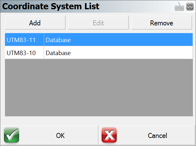
Add
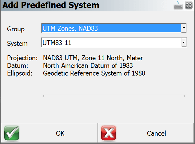
Add a new coordinate system to the list by one of three methods:
- Select Coordinate System From Database - Select one of the predefined coordinate systems. Coordinate systems are grouped into countries or mapping systems. Select the country or system that you are surveying in and then choose the coordinate system in the System drop down list. The section below the System field displays the projection, datum, and ellipsoid information related to this coordinate system.
- Create New User Coordinate System - Create a completely new coordinate system from scratch with known parameters. Enter a name for your coordinate system and optionally enter a description. NOTE: The system name must have colon in the name.
- Create New User Coordinate System From Database Selection - Choose a predefined coordinate system to populate parameters for a new coordinate system.
Edit
Edit a user-defined coordinate system. It is not possible to edit predefined coordinate systems.
Remove
Remove the selected coordinate system from the list. If the coordinate system is user-defined; you will have the option to permanently delete the coordinate system. You may want to use the User Coordinate System Export routine to save a backup copy of your user-defined coordinate system before removing it permanently.
OK Button
This will save the coordinate system favourites list to the MSurvey.ini file.
Cancel Button
This will exit the dialog and will save nothing. You will be automatically returned to the Coordinate System Settings dialog.
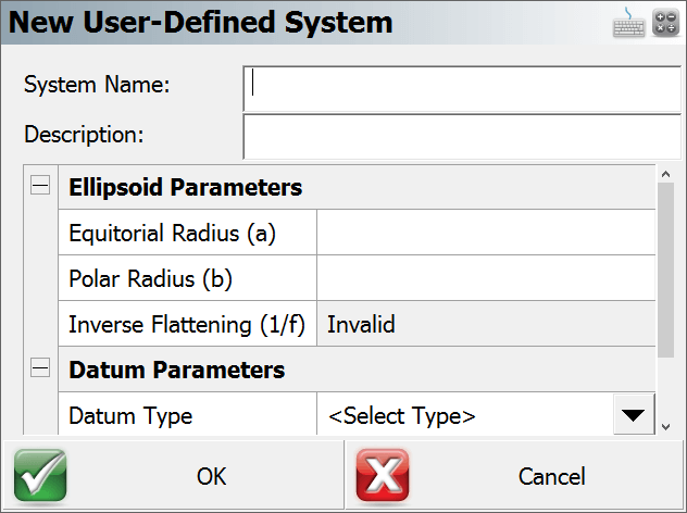
New / Edit user-defined Systems
Ellipsoid Parameters
To define the ellipsoid for the coordinate system you must enter the known equatorial and polar radiuses for the ellipsoid. The Inverse Flattening is not editable and will be computed automatically and can be used a check.
- Equatorial Radius (a)
- Polar Radius (b)
- Inverse Flattening (1/f) - Always a read only value, automatically computed from the two ellipsoid radiuses.
Datum Parameters
There are 7 datum types to select from:
- Three Parameter
- Four Parameter
- Six Parameter
- Seven Parameter
- Bursa / Wolf
- DMA Molodensky
- None
If none is selected then no transformation parameters will be applied to the coordinate system transformation.
If a datum other than none is selected then the user will be able to enter the following parameters:
- Delta X (m)
- Delta Y (m)
- Delta Z (m)
- X Rotation (“)
- Y Rotation (“)
- Z Rotation (“)
- Scale (PPM)
Projection Parameters
The user can select one of nineteen projections.
- Lambert Conformal Conic (One Standard Parallels)
- Lambert Conformal Conic (Two Standard Parallels
- Transverse Mercator or Gauss Kruger
- Universal Transverse Mercator
- Albers Equal Area Conic
- Rectified Skew Orthomorphic, Azimuth at Projection Center
- Mercator Cylindrical Projection with Standard Parallel
- Mercator Cylindrical Projection with Scale Reduction
- Lambert Azimuthal Equal Area
- Lambert Azimuthal Equidistant
- Miller Cylindrical
- Oblique Sterographic
- Polar Sterographic
- Sinusoidal Projection, Optionally Interrupted
- Equidistant Cylindrical
- Cassini
- Robinson Cylindrical
- Bonne Pseudoconical
- Krovac Oblique Conformal Conic, Czechoslovokia
Typical projection parameters for most cases are:
- Scale Factor
- Central Meridian
- Origin Latitude
- Origin Longitude
- False Northing
- False Easting
Automatic Backup
Whenever you add or edit a user-defined coordinate system, FieldGenius will automatically create and save your parameters to a file named user-coordsys-backup.csmap to the mapping directory.
This backup file stores your user-defined coordinate systems. If you accidentally remove or overwrite your user-defined coordinate systems, you can re-import them from this backup file using the Import user-defined Coordinate System command.
Localization (Site Calibration)
Further coordinate transformations can be accomplished with the use of the Local Transformation function of FieldGenius. See the GNSS Local Transformation section for more information.
These settings are stored in your Project's INI file, allowing you to easily use different coordinate systems for different Projects.