ASCII Coordinate Export
Main Menu | Import / Export | Points / Observations | ASCII Coordinate Export
Use this option to export a coordinate list from the current file.
This is useful for transfer of points from one file to another.
Function
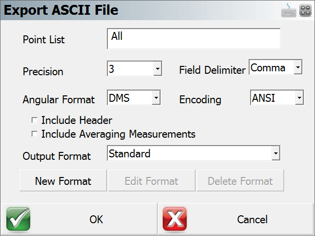
- Specify a range of point to export in the form #..#. Accept default of All if desired.
- Specify the number of decimal places to carry on the export. (maximum=6)
- Specify if you want to export them with either a space or comma delimiter.
- Specify the Angular format.
- Specify the Encoding format.
- ANSI - This is the default format for ASCII, which is compatible with majority of the CAD programs such as Autodesk products.
- UNICODE - This is for use with non-English characters in the Description or Note fields.
- Include Header will add a header row to the exported file.
- Include Averaging Measurements - This will include all the temporary observations of all the averaged points into the exported file
- Choose the file format type that you want to use. See below for more details about the different file formats. If you are uncertain, use the Standard format.
- Choose Export to export the coordinates, or Cancel to abort the export.
- Browse to the folder where you want to save the file, enter a filename including an extension, then press Save File. FieldGenius will not add any extension to the filename you enter.
- You will be shown a confirmation of how many points were exported.
File Formats
Both space and comma delimited files are supported.
For all formats, the order of the Northing and Easting fields are determined by setting the Coordinate Order in the Options screen.
Standard
ID, Northing/Y or Easting/X, Easting/X or Northing/Y, Elevation, Description:Note
This format will append any notes you have to your description, separated by a colon.
FieldGenius has recently added two check boxes to include the Header and the Averaging Measurements to the ASCII file when exporting.
Extended
ID, Northing/Y or Easting/X, Easting/X or Northing/Y, Elevation, Description, Note, Latitude, Longitude, EllipsoidalHeight, LatitudeStdDev, LongitudeStdDev, HeightStdDev
This format is different than the Standard such that notes are separated from descriptions.
If you collected GNSS data, the WGS 84 information will also be exported along with other information related to the GNSS point. The WGS 84 information will be extracted from your GS records in the raw file.
Extended with Header
Same as the Extended format, but with Header data in the first row.
CST
This is a predefined format intended for Leica ELLIPSE Neo software
Custom Formats

FieldGenius has the option to create a customized ASCII file for exporting. This option allows the user to add additional information to the standard ASCII file format. Simply click in the grey area to add in an extra info line and select what you wish to add in from the pull down menu.

There is also an "Options" button in the upper right corner where you can specifically request the ASCII file to either sort by Point ID or Measurement type as select what GNSS time format.
More about the Extended Format
If you import a FieldGenius extended file format ASCII file, we will create EP and GS records in the raw file. Also, the coordinates will be imported and stored in the database.
There is more detailed information about the extended format in the ASCII Coordinate Import topic.