Points / Observations
ASCII Coordinate Import
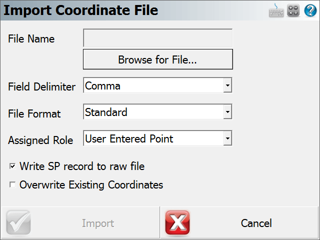
Main Menu | Import / Export | Points / Observations | ASCII Coordinate Import
Use this option to import a list of coordinates to the current Project.
This may be required if a separate coordinate file is uploaded to the device by itself (not as part of a Project with linework). This is also useful for transfer of points from one file to another.
Function
- Click on the "Browse for File..." button to navigate to and select your file.
- Choose the field delimiter, either Comma or Space.
- Choose the file format. See below for more information regarding file format. If you are uncertain, use the Standard format.
- Use the assigned role field to select the survey role of the points being imported. If these points are to go into the
- Write SP (Store Point) record to raw file will store the imported coordinates to the raw file. This is very useful if you wish to reprocess coordinates later, so we recommend that you select this when importing points.
- Overwrite Existing Coordinates - allows you to control whether points will be overwritten during the import.
- Set as Control Points – will set a flag in the database that will prevent these points from being edited or changed in FieldGenius (under any circumstances!)
- Choose OK to import the coordinates, Cancel to abort the import.
- You will be shown a confirmation of how many points were imported to the current Project.
File Formats
Both space and comma delimited files are supported.
For all formats, the order of the Northing and Easting fields are determined by setting the Coordinate Order in the Options screen.
Standard
ID, Northing/Y or Easting/X, Easting/X or Northing/Y, Elevation, Description:Note
This format expects the file to be in a standard ASCII format. If your descriptions have a colon in them, then FieldGenius will store everything before the colon as a description, and everything after the colon will be considered to be a note.
Standard with Header
Same as the Standard format, but the first row in the file is ignored.
Extended
ID, Northing/Y or Easting/X, Easting/X or Northing/Y, Elevation, Description, Note, Latitude, Longitude, Ellipsoidal Height, Latitude StdDev, Longitude StdDev, Height StdDev
This format is different than the standard such that notes are separate from descriptions.
Extended with Header
Same as the Extended format, but the first row in the file is ignored.
More about the Extended Format
If you import a FieldGenius extended file format ASCII file, FieldGenius will create EP and GS records in the raw file. Also, the coordinates will be imported and stored in the database.
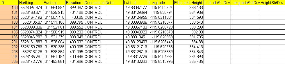
Importing Cartesian and Geodetic Coordinates
Above is an example of an Extended ASCII file. For the format to work correctly, each point should include Cartesian and Geodetic coordinates for each point.
So if this type of file is imported into FieldGenius the following will occur:
- A point is stored in the Project database using the Cartesian Coordinates.
- A GS record is written in the raw file using the Cartesian Coordinates as a reference.
- An EP record is written to the raw file using the Geodetic Coordinates as a reference.