GNSS Tolerance Settings (Rover)
Main Menu | Connect | Edit Profile | Tolerance Settings
GNSS Toolbar | Instrument Settings | Sensor Configure | Tolerance Settings
The tolerances settings are used to enter information used in computing the position of the rover once a GNSS measurement has begun.
You can define three different tolerance modes that can be selected from the Sensor Configure option in the GNSS Settings menu while surveying. Tolerance settings are used to ensure that certain criteria are being met every time you take a measurement. The reason for three different settings is to allow you to specify different tolerances for different types of measurements you might need to make. For example, control points would need to be measured more precisely then those used for topographic measurements.
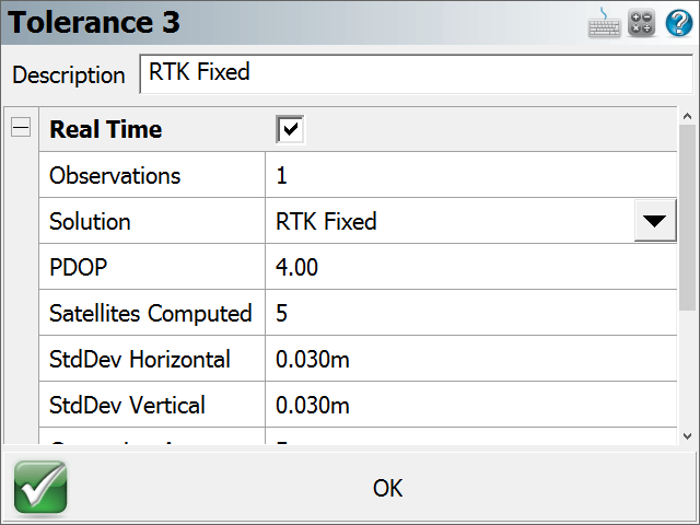
Description
This is where you can assign a "friendly" description to your three tolerance modes to make them more easily identifiable to you - for example "Control Points" or "Topo Points".
Options
Real Time
Toggle to set the Tolerance Settings for RTK.
Observations
This is the minimum number of observations that the receiver must collect and average in order to compute a solution.
Solution
Each observation must be of the specified solution type (or better). You can select from several Solution modes depending on your receiver make and model, these can be:
- Autonomous
- SBAS (Satellite-based Augmentation System)
- DGPS (Differential Global Positioning System)
- RTK Float (Differential Carrier Solution)
- RTK Fixed (Differential Carrier Solution)
Please refer to your GNSS manufacturer's documentation for the solutions' respective positional accuracy.
Elevation Mask
The elevation mask is used to filter out satellites that are close to the horizon and are, thus, unreliable. Typical elevation mask angles can range between 10º and 20º.
PDOP
The PDOP (Position Dilution of Precision) mask is used to control the acceptable geometry of the satellites used to compute the solution. If the PDOP value exceeds this number, the user will not be eligible to collect a position. Typical PDOP masks are 5 or 6.
Satellites Computed
The Satellites mask is used to establish the minimum number of satellites that are necessary to produce a solution with a valid position. Each satellite must also pass the elevation mask test to be included in this number for the calculation of the rover position.
StdDev Horizontal
FieldGenius will use the instantaneous Standard Deviation values that your receiver is outputting to determine if the measurement can proceed. If the instantaneous Standard Deviation values are equal to or less than the values you've specified, then the measurement can proceed. Once this happens, FieldGenius will start averaging the measurements and will compute and display averaged Standard Deviation values. These averaged Standard Deviation values must then remain equal to or less than the values you've specified for the entire duration of the measurement, for the measurement to be accepted as being within the specified tolerances.
This is your maximum acceptable horizontal standard deviation to be maintained during the point measurement.
StdDev Vertical
This is your maximum acceptable vertical standard deviation to be maintained during the point measurement.
Correction Age
The maximum time (in seconds) since correction data was received.
Point Tolerance
Point Tolerance - Observations
This is the minimum number of observations that the receiver must collect and average in order to compute a solution.
Point Tolerance - Time
This is the minimum time duration that the receiver must collect and average observations in order to compute a solution.
Post Processing Tolerances
These settings apply when using FieldGenius to collect static data for later post processing.
Please note that FieldGenius does not support collecting raw data on all GNSS receivers, please refer to the Raw Data Logging topic for additional details including a list of receivers which support this function.
Usage
This option determines whether FieldGenius should use Post Process mode to collect static data for later post processing.
Selecting Always instructs FieldGenius to automatically switch into Post Process mode to collect static data for all points.
Selecting Auto Start instructs FieldGenius to automatically switch into Post Process mode to collect static data for the point currently being measured, if the current solution masks are not met.
Selecting Manual allows you to switch into Post Process mode to collect static data for any point as it is being measured, but FieldGenius will not do so automatically.
Time - Less than 5 SVs
This defines the duration of the static collection if the minimum number of satellites being tracked during the static session is 4 satellites. Default = 30 minutes.
If at any time the number of satellites drops below 4 (which is the minimum number of satellites required to post process a 3D solution), the internal clock timing the static session will reset to zero and begin again.
Time - Less than 6 SVs
This defines the duration of the static collection if the minimum number of satellites being tracked during the static session is 5 satellites. Default = 25 minutes.
Time - Less than 7 SVs
This defines the duration of the static collection if the minimum number of satellites being tracked during the static session is 6 satellites. Default = 20 minutes.
Time - Less than 8 SVs
This defines the duration of the static collection if the minimum number of satellites being tracked during the static session is 7 satellites. Default = 15 minutes.
Time - 8 or more SVs
This defines the duration of the static collection if the minimum number of satellites being tracked during the static session is 8 or more satellites. Default = 10 minutes.