Real-time DTM Surface
FieldGenius creates and manipulates a 3D surface from data collected in the field or from data imported through LandXML, QSB or ASCII point files. A FieldGenius surface is a mathematical description of a surface that exactly honors all input 3D data points and lines.
A Surface represents the existing topography of a job site. Surfaces contain one or more parts such as points, breaklines, triangulated irregular networks (TIN), or triangulated grids (TGRID).
A surface is not a drawing entity, rather it is a mathematical description held in the data collectors memory. Representations of a surface, such as contours, TGRIDS or TINS may be drawn into your diagram as polylines and polyface entities.
Creating a Real-time DTM in FieldGenius
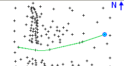
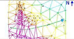
FieldGenius will compute a DTM model from points collected, staked, or imported from any ASCII file and from any existing FieldGenius project. There are no limits to the number of points that are used to create the DTM. The AutoMap Library controls what points and/ or lines are included or excluded from the DTM surface. The DTM is created in real time and can be appended as additional points are picked up.
To create a DTM, follow the instructions below:
From Main Menu | Data Manager | Surfaces you can turn on the Realtime DTM Surface by placing a checkmark in the box before the "Point Database" surface. Expanding the tree will allow you to define whether it is displayed as Contour Lines, Solid Faces, and/or Triangle Edges.
The surface can be viewed or used in volume computations immediately.
Before turning on the Point Database surface:
After turning on the Point Database surface:
Each point in the database has an attribute called "DTM State". This can be set to "Do not Include". If you set a point to this value, you will see that the surface no longer includes this point. This only applies to the current surface that is computed in FieldGenius. It does not apply to surfaces imported from a QSB or LandXML file.
What is the difference between a TIN and a TGRID?
The user should become familiar with both options and decide which option is best suited for their project.
TIN honors breaklines but may be too restrictive for contours to follow the natural flow of the terrain. Contours around small hills may look jagged if too few data points were collected.
TGRD honors breaklines and allows the contours to follow the natural flow of the terrain. Contours around small hills will look better if the TGRD option is used.
Generally, the TGRDis for cases where you want curvature introduced between your data points and you have breaklines. This is most easily shown with an example:
Adding Breaklines to a Surface
If a break in the slope continuity is desired, the user MUST ALWAYS use the TIN or TGRD (Triangulated Grid) in conjunction with breaklines. When modeling a surface containing breaklines, a TIN or TGRD honors breaklines exactly.
What happens when you add breaklines?
Breaklines represent 3D continuous traces in space (think of them as a 3D polyline) which:
- Define the surface elevation
- Force slopes to be different on either side of the breakline
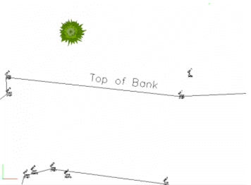
This line represents a location at the site where the slope changes from a steep hill to a relatively flat area.
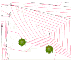
Contours Generated without use of Top of Bank breakline:
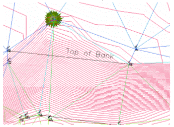
Without a breakline, the contours "flow" over the top of the bank and the contours do not look correct.
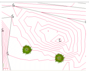
Contours generated with use of Top of Bank breakline:
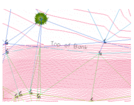
With a breakline, the contours are forced to honor the line, as a change in slope that helps the contours to look correct.
Breakline Control
The user would want to use a figure as a breakline in the triangle formation process (TIN) for the edge of pavement, but probably not for a line connecting points that are not related to the surface features. An example of this might be a chain connecting legal boundaries as they might cross over roads or creeks without consideration for the existing topography.
Breaklines are used in the creation of the DTM by forcing the triangulation to follow them. Triangles created in the DTM cannot cross a breakline. The edges of the triangles will always follow the breakline. When necessary, FieldGenius will automatically densify the DTM along the breakline to create triangles that conform to the breaklines. This helps with the creation of accurate surface models and contours. FieldGenius contains the exact same functions for surface modeling, contouring, and volumes as MicroSurvey CAD or inCAD.
Contouring
Creating contours in FieldGenius is a simple as choosing the desired DTM surface from the dialog and checking the contour option:
The procedures for contouring a DTM surface are outlined below:
-
Open the Surface Settings dialog.
-
Type in the appropriate Contour Interval. The default interval is every 2 units.
-
You can control the Minimum Elevation. This is useful if you have some data that is displayed at a zero elevation (example: alignment point data that is horizontal) and you want to exclude these points.
-
If you want to create a TGRID, then turn on the Gridded TIN option, or leave this off to create a TIN. The Grid Size is a ground unit value that will determine the spacing of the grid lines.
-
Press OK to return to the Surface Manager screen.
-
Finally, turn on the contours by expanding the Point Database surface and selecting the Contour Lines option to display them.
-
Close the Surface Manager and return to the map screen to see your contours.