Surface Settings
Main Menu | Data Manager | Surfaces | Settings
View Toolbar | Surface Manager | Settings
Use the surface settings screen to define settings that affect TIN (Triangular Irregular Network), TGRID and Contours.
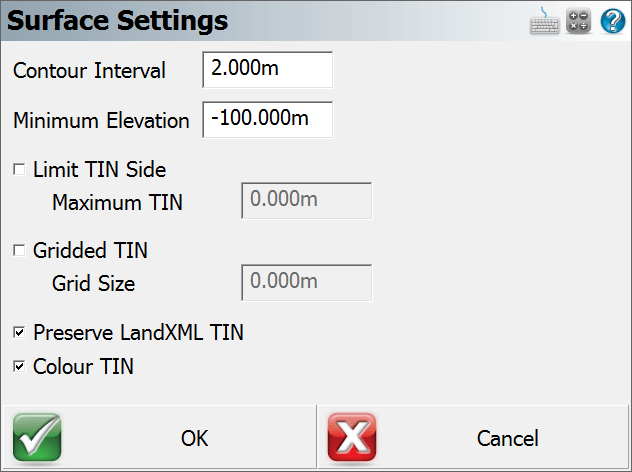
Contour Interval
This will force the contours to be drawn at an interval equal to the value set here. The interval is equal to the drawing units.
Minimum Elevation
This controls the minimum elevation. This is useful if you have some data that is displayed at a zero elevation (example: alignment point data that is horizontal) and you want to exclude these points from the surface.
Limit TIN Side
This will determine the max length that will be allowed for a TIN triangle.
Gridded TIN
If this is on, when you draw the surface it will be represented using a TGRID model instead of a TIN model. TGRID surfaces will apply smoothing in areas that have no breaklines. This may create better quality contours. The Grid Size is a ground unit value that will determine the spacing of the grid lines. If the Grid Size is 0 then a grid size will be automatically calculated.
Preserve LandXML TIN
This will force the surface to be loaded using information stored in the LandXML file. A LandXML surface will be defined in such a way that each triangle corner is defined by a point id. These points are stored in the file as CgPoints, so FieldGenius will honor these faces and not re-compute a new surface.
Color TIN
When this is turned on then the surface color will be determined by the triangles' elevation. When turned off the surface will be displayed using a gray color. If the TIN's wireframe and solid faces are both being displayed, then the faces will be colored but the wireframe will be gray for better visibility.