Horizontal Angle Offset
Main Menu or Instrument Toolbar | Measure Mode | Offsets | Horizontal Angle Offset
FieldGenius includes a flexible angle offset routine. It allows you to shoot the angle and distance to a point that cannot be occupied by the rod. An example of where you would use this is if you wanted to record the center of a large object, such as a tree.
When you choose the Horizontal Angle Offset Measure Mode you will see the following screen.

Two observations are required: one to record the angle to the point of interest, and a second to measure a distance perpendicular to the point.
On this screen you determine what order you will make these two measurements. All you need to do is press either the Observe Angle or Observe Distance button.
Note: You can increase the size of the text shown in the grid by setting the Text Size option in the Options screen.
Note: The Quick Measure Modes option in the Options screen will affect what happens when you press the Observe buttons when you are using the offset routines. If Quick Measure Modes is on, a measurement will automatically be taken. If it is off, the Observe button doesn't actually trigger your total station to take a measurement; it simply takes you to the map screen where you can press the measure button once you are ready to take the measurement.

Angle (Center)
This will record the total station's horizontal angle. When measuring the angle, you should point the total station towards the center of the new point that will be created. This would be measurement "A" in the diagram shown above.
Note: You do not need to sight a prism to record the angle, simply sight the new point and press the Observe Angle button.
Distance
This will record a distance, measured to a prism which is located at the side of the object. You should try to locate the prism so that it is perpendicular to the center of the object and the line-of-sight from the total station. This is measurement "B" in the diagram shown above.
Note: The target height is important on this shot, because the new point will have the same elevation.
Storing the Shot
After you record your measurements you can store the new point by pressing the Store Point button.
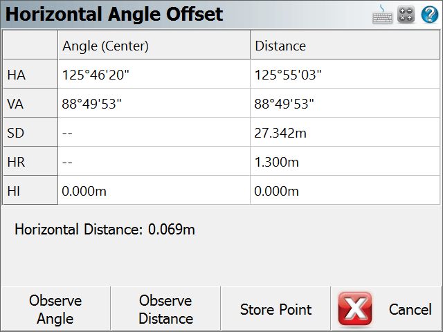
After you store the point, you can continue using the offset command to record additional points, or exit it by pressing the Cancel button.
Raw File Record
In the raw file the OF records represent the measurements that were made and the SS record is derived using the two OF records
OF,AR94.49380,ZE88.41340,SD27.3163
OF,OL93.25450,--Right Angle Offset
SS,OP1,FP23,AR93.25450,ZE88.41340,SD27.3081,--ROAD