Line - Angle Intersection
Main Menu or Instrument Toolbar | Measure Modes | Intersections | Line - Angle Intersection
The Line-Angle Intersection command is used to define two points that will be used to establish a reference line then measure an angle that intersects this reference line, and FieldGenius will automatically compute the coordinate at the intersecting point.
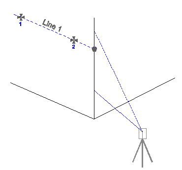
An example of where you might use this is to locate the corner wall of a building. Simply shoot two points on one of the walls, then turn the instrument so it is pointing anywhere along the corner of the building. This command is intended to be used with reflectorless total stations.
Measure Points
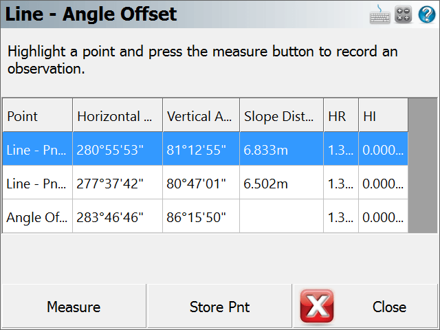
When you start the Line-Angle Intersection command, you will see an empty list.
Highlight the row that you would like to make a measurement for and simply press the Measure button to begin the measuring process.
If you need to redo a measurement, simply highlight it in the list and press the measure button.
Notes:
1. You can shoot the points in any order you like, FieldGenius will determine what direction to go in to compute an intersection
2. The northing and easting values for the new point will be computed using the intersection of the line and the angle that was read.
3. The z value for the new point will be computed using the projected elevation along the reference line to the point where an intersection is computed.
Note: You can increase the size of the text shown in the grid by setting the Text Size option in the Options screen.
Store the Point
Once you've made your measurements that will be used to compute the intersection, you can press the Store Point button. This will store a point in the map screen, store a point in the database as well as record information to the raw file.
Raw File
Everything about the intersection is stored in the raw file.
--Line - Angle Offset
--HI1.340,HR0.000,AR280.55530,ZE81.12550,SD6.8330,--Pnt 1 of Line
--HI1.340,HR0.000,AR277.37420,ZE80.47010,SD6.5020,--Pnt 2 of Line
--HI1.340,HR0.000,AR283.46460,ZE86.15500,--Angle Offset
SP,PN4,N -0.0050,E 0.0051,EL0.5761,--