Javad
Conversion:
Javad has the option to export the GPS data to STAR*NET in their J-Field Software.
Notes:
The export to STAR*NET should create a .GPS file for you to add to your STAR*NET project.
Some changes to the exported file will need to be made in STAR*NET before the file will adjust:
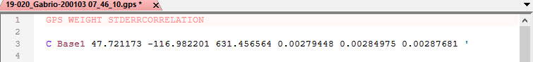
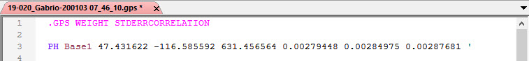
- Add a "." to GPS Weight STDERRCORRELATION so that it turns PINK
- Remove the "C" record for the base and change it to a "PH" record to reflect latitude, longitude and ellipsoid height
- You will need to convert the Latitude and Longitude of the Base location to Degree's Minutes and Seconds (DMS) from Decimal Degrees
See below for an example:
Before changes:
After changes:
*This solution was discovered using J-Field v 3.0.2.1151